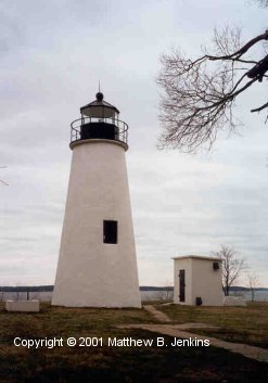
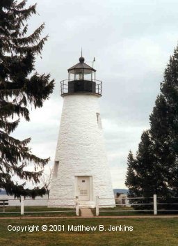
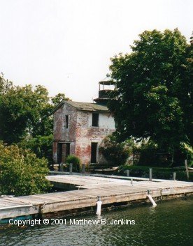
Chesapeake Bay Lighthouse Project

Northern Bay Lights


Concord Point

Concord Point Light
Havre de Grace, MD
cir. 1838

The Concord Point Lighthouse was commissioned in 1827 to warn ships of currents and shoals at where the northern tip of the Bay meets the Susquehanna River. It stands 39 feet high. Like many of the Bay's old tower lights, it was designed and built by John Donahoo out of Port Deposit granite. Several upgrades to the lighting apparatus were made over the years, cumulating in a fifth order Fresnel lens. The station was electrified in 1920 and served until 1975 when it was decommissioned by the Coast Guard. Its 148 years of continuous use are the longest of any lighthouse in Maryland. The tower sits in the middle of what is now quite a nice little park in the old section of scenic Havre de Grace, Maryland. There are plans for renovating the near-by keeper's dwelling and the new Havre de Grace Maritime Museum has recently opened across the street.

(U.S. Coast Guard Historian's page - Concord Point Light)


Fishing Battery Light

Fishing Battery Light
South of Havre de Grace, MD
cir. 1853

Fishing Battery is a small, low-lying, Bay island south of Havre de Grace, MD that had been used for pulling in fish nets from the Susquehanna Flats. In the late 1800s it was also the location of a state run fish hatchery. A small, one story, brick dwelling with a wooden rooftop lantern was built by John Donahoo in 1853 and is the last lighthouse constructed by Donahoo on the Bay. In 1887 major upgrades were made. A new foundation was laid and the building was enlarged. The keepers quarters were moved to the second floor with the ground floor used as a boat / utility shed area. In 1921 the light was moved out of the rooftop lantern to a steel tower built right next to the dwelling. This, in turn, was automated in 1939 and is still an operating aid to navigation. The island is now owned by the Department of the Interior and is considered part of the Blackwater Wildlife Refuge. It is a popular place for small boats to go for picnics and the old lighthouse structure has suffered from a great deal of both vandalism and neglect over the years. In particular much of the interior woodwork, including stairs and shutters has been torn down and used for beach fires. It is currently in a great state of disrepair and open to the elements.

(U.S. Coast Guard Historian's page - Fishing Battery Light)


Turkey Point

Turkey Point Light
Elk Neck State Park, Northeast, MD
cir. 1832

Turkey Point light, which was commissioned in 1833, sits atop a high peninsula bluff which separates the Elk and Northeast rivers. Its purpose was to guide ships to the newly built Chesapeake and Delaware Canal. Like the not too distant Concord Point Light, This 35 foot stone tower was built by John Donahoo and shared the same basic plans. It is somewhat remote in terms of land access and for many years a winch was used to haul supplies (which were brought by boat) up the bluff. The light was staffed until 1947, after which Fannie Slater, the Bay's last female lighthouse keeper, retired from service there and it was fully automated. The keeper's house had to be torn down in 1972 because of decay and vandalism. The bluff and lighthouse are now part of Elk Neck State Park and are located at the end of a nice walking trail. It is now managed by Turkey Point Light Station, Inc. and still functions as an active aid to navigation.

(U.S. Coast Guard Historian's page - Turkey Point Light)


Pooles Island

Pooles Island Light
Pooles Island, MD
cir. 1825

Pooles Island lies north of Baltimore in the center of the Chesapeake and used to be home to a small agricultural community. The lighthouse tower and keeper's dwelling were built in 1925 by John Donahoo and Simon Frieze. It is the first lighthouse built by Donahoo and the oldest still standing in Maryland. Constructed of Port Deposit granite the tower stands 40 1/2 feet tall. In 1828 a fog bell tower was added and in 1882 the keeper's dwelling was enlarged. The Island, including the lighthouse were acquired by the Army in 1917 and the light was automated at that time. It is now part of Aberdeen Proving Ground and is off limits to the public. In 1939 the light was deactivated and the keeper's dwelling torn down. The tower subsequently fell to a fairly poor state of repair. However, in 1996 the Army launched an effort to restore it. The lantern and tower were stripped, re-parged, and painted. New windows and doors of the original style were installed. There are plans to launch a second phase, interior, restoration and a hope to eventually re-light the tower.

(U.S. Coast Guard Historian's page - Pooles Island Light)


Seven Foot Knoll

Seven Foot Knoll Light
(moved to) Inner Harbor, Baltimore, MD
cir. 1855

This is the second screwpile light built on the Bay out of over 40 and the first built in Maryland. Unlike most of the others, however, it is built entirely of iron and its circular design is unique among the Bay's screwpiles. Seven Foot Knolls is at the mouth of the Patapsco River. Though ice flows threatened the structure on several occasions the damage was repaired and several shoring projects undertaken throughout the years. In 1933 one of its keepers, Thomas Steinhise, received a Congressional medal for heroism after braving a storm in his small skiff to single-handedly rescue the crew of a foundering tugboat. (This same storm severed the peninsula on which New Point Comfort Light stood.) The light was automated 1848 and by the 1980s was badly damaged by corrosion, and vandalism. In 1988 ownership was transferred to the city of Baltimore and it was moved by barge to Pier 5 at Inner Harbor. It is now open to the public along with the lightship Chesapeake.

(U.S. Coast Guard Historian's page - Seven Foot Knoll Light)


Lightship Chesapeake

Lightship Chesapeake, LV 116 / WAL 538
(moved to) Inner Harbor, Baltimore, MD
cir. 1930

This 133 foot ship was built in 1930 by the Charleston Drydock and Machine Company in Charleston, South Carolina for a contract price of $274,434. Powered by a 350 HP diesel electric engine, in her heyday she was capable of 10 knots. Like most other lightships, she was assigned to several stations throughout her career and would have born the name of that station during the assignment: 1930 - 1933: Fenwick Island Shoal (DE); 1933 - 1942: Chesapeake (VA); 1942 - 1945: Examination Vessel, WW II (during which she was armed with two 20 mm cannon); 1945 - 1965: Chesapeake (VA); and 1965 - 1970: Delaware (DE). She was the last of six lightships assigned to the Chesapeake lightship station at the mouth of the Bay where she worked until being replaced by the current "Texas tower" style lighthouse. Upon retirement, she took back the name "Chesapeake" and was transferred to the National Park Service and put on display. In 1982 Chesapeake was moved to Baltimore's Inner Harbor where she is docked as a living museum. She is now a National Historic Landmark.


Fort Carroll

Fort Carroll Light
Patapsco River, outside Baltimore MD
cir. 1854

Somewhat similar in appearance to Fort Sumter in South Carolina, Fort Carroll sits a top a man-made island in the middle of the Patapsco River and protects the approach to Baltimore. Construction on the hexagonal fort began in 1847 and Robert E. Lee oversaw a phase of the construction before becoming superindendent of West Point. By the time of the Civil War it was only partially completed and minimally gunned. The original plans called for four tiers supporting 225 guns. However, by the latter 1800s fortifications of this type were obsolete and only one story was completed. The small lighthouse, with a sixth order Fresnel lens, was added to the fort in 1854 and moved several times during the fort's construction. It was later re-built in 1898. The fort was abandoned after World War I. It was used again briefly during World War II (this time by the Coast Guard). After the war both the lighthouse and the fort were abandoned for the final time. It is now quite overgrown and the lighthouse is in a great state of decay.

(U.S. Coast Guard Historian's page - Fort Carroll Light)


Craighill Channel Range Lights
Entrance to the Patapsco River, MD

Unlike most lighthouses on the Bay, which warn of shoals, these four lights mark a channel. Named after an engineer and longtime member of the lighthouse board, Craighill Channel cuts roughly five miles off the southern approach to Baltimore, entering Brewerton Channel (the main Patapsco River / Baltimore channel). Range lighthouses are used in pairs. Each one of the pair supports a light of different heights. When the two lights are aligned one is in the channel. The Craighill Channel range lighthouses are really two separate sets of lights built a bit over ten years apart. The existence of four lights with the same name creates a certain amount of confusion. Additionally, one notes on the chart that lower range lights are located further north (i.e. "up") than the upper range lights which are further south (i.e. "low"). The reason for this is sensible - The lower range lights mark the lower end, or beginning, of the channel. When the second set of lights come into line, a ship turns into the upper end of the channel. All four of these lights are still active navigational aids.


Craighill Channel Range - Lower Rear

Craighill Channel Lower Range Light - Rear
Entrance to the Patapsco River, MD
cir. 1873

Originally the lighthouse board recommended a screwpile light for this location. However, the winter of 1872 - 73 was particularly severe and, in light of ice-related problems encountered with other screwpile lighthouses, a "more solid" structure was decided upon. This entailed building a cofferdam, and laying nine granite supporting piers. On these piers was built a 105 foot, four-sided, iron frame enclosing a two-story Victorian keeper's house with a rectangular tower rising through the center with two levels of balconies by the lantern. The architecture of this light is unique in the Bay. Unfortunately, the interesting keepers dwelling was torn down in the 1930s when the light was automated.


Craighill Channel Range - Lower Front

Craighill Channel Lower Range Light - Front
Entrance to the Patapsco River, MD
cir. 1873

This is the first caisson light built on the Bay and the first built in the United States. It represented the cutting edge of lighthouse construction at its time. Construction involved a number of difficulties, including a bottom so soft a piling would sink 20 feet under its own weight. This made setting the foundation extremely difficult. Finally groups of piles were driven deeply and flush into the mud and the caisson set on top of this base. Extensive rip rap stone was also laid. This lighthouse supports two lights - a standard fourth order Fresnel lens in the lantern, and the separate range light mounted on the side. It was used by the Coast Guard as a radio transmission station, so was not fully automated until 1964.


Craighill Channel Range - Upper Rear

Craighill Channel Upper Range Light - Rear
Entrance to the Patapsco River, MD
cir. 1886

Thirteen years after establishment of the original Craighill Channel range lights, a second set of range lights were constructed to mark a new, upper, cutoff between Craighill and Brewerton channels. These second set of lights are built on a much less ambitious scale than the first. The rear light consists of an iron frame supporting a wooden tower that is covered with corrugated iron. A locomotive headlight was used as the original lantern and the keeper lived in a house next to the tower. The light was automated in 1929.


Craighill Channel Range - Upper Front

Craighill Channel Upper Range Light - Front
Entrance to the Patapsco River, MD
cir. 1886

The front light of the Craighill Channel upper range sits upon the foundations of an earlier lighthouse - the old North Point light. That light had been deemed unsuitable for incorporation into the new range, so was torn down and replaced with the current, small, red and white brick, octagonal tower. Originally a keepers dwelling was located on shore and a wooden bridge connected the light to the shore. However, this was destroyed by a storm in 1893. Rather than re-build the bridge, it was decided that the keeper would move into the less than twelve foot square lighthouse and use a small skiff to get to shore. The accommodations were so cramped that the lantern had to be relocated on the outside of the tower. Like its companion light, it was fully automated in 1929.

(U.S. Coast Guard Historian's page - Craighill Channel Range Lights)


Baltimore Light

Baltimore Light
Mouth of the Magothy River, MD
cir. 1908

Despite its name, this caisson lighthouse isn't particularly close to the city of Baltimore. It does, however, mark the entrance to the Baltimore channel. From the beginning, construction was fraught with problems. The bottom of the Bay at this site has a 55 foot layer of semi-fluid mud before solid sand is hit. This posed great engineering problems and a contractor could not be found that would bid within the originally appropriated amount. Later, during construction, the structure turned completely over on the bottom and the contractor (an experienced firm that had built several other caisson lights on the Bay) abandoned the project. After some legal battles, the insurance company took over the project. The light was commissioned in 1908, thirteen years after construction work began. The caisson goes down 82 feet below high water line, which had made it the largest caisson lighthouse in the world. This light is also notable in that it was the first nuclear powered lighthouse in the world. A 60 watt generator, about the size of 55 gallon drum was installed in 1964. However, it was removed after only two years and the idea was not pursued further.

(U.S. Coast Guard Historian's page - Baltimore Light)


Copyright © 2001, Matthew B. Jenkins